What Do Mt. Horeb, The Mountain of God, Mt. Paran and Mt. Seir Have to Do with Mt. Sinai?

Share/recommend this article:

Excerpt The short answer to our title question is that the Mountain of God, Mt. Horeb, Mt. Sinai and Mt. Paran are all names for Mt. Sinai, and Mt. Seir is important for determining the location of Mt. Sinai. The long answer... Continue reading

Explore
Related Articles
Support
Like this artice?

Our Ministry relies on the generosity of people like you. Every small donation helps us develop and publish great articles.

Please support ABR!

Visa, MasterCard, American Express, Discover & PayPal

The short answer to our title question is that the Mountain of God, Mt. Horeb, Mt. Sinai and Mt. Paran are all names for Mt. Sinai, and Mt. Seir is important for determining the location of Mt. Sinai. The long answer, which is the subject of this article, is that each of these names provides important clues for determining where Mt. Sinai is located. The location of Mt. Sinai is one of the major mysteries in Biblical research. Yohanan Aharoni has stated, “To-day the problem of identifying the route of the Exodus and Mount Sinai itself is one of extraordinary difficulty, far more than any other problem of Palestinian Biblical topography” (1962: 118).

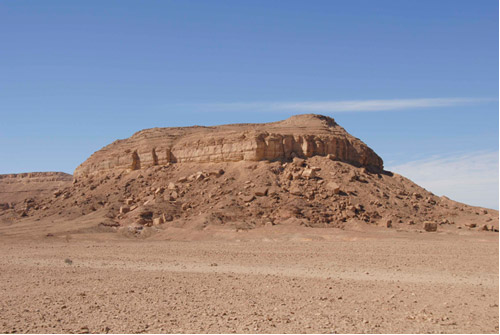
Gebel Khashm et-Tarif, a mountain explored by the Associates for Biblical Research in 2007. Located ca. 22 miles west-northwest of the northern end of the Gulf of Aqaba/Elat, it is the only site thus far proposed that meets all of the Biblical requirements for Mt. Sinai.

Mt. Sinai: The Site of Important Biblical Events

Mt. Sinai occupies an important place in human history, as well as in the history of God’s people. Most significantly, it was the place where God appeared in person to Moses and gave him the law. Earlier, at the end of Moses’ 40-year exile in Midian, God appeared to him in a burning bush at the base of the Mountain of God and called him to return to Egypt to lead the Israelites to freedom (Ex 3:1–4:17). When the Israelites first arrived at Mt. Sinai, Moses struck a rock at Horeb to provide water for the multitude (Ex 17:6). They then spent 11 months at the holy mountain before breaking camp and moving on to Kadesh Barnea.

Shortly after arriving at Mt. Sinai, Jethro, Moses’ father-in-law, visited Moses and advised him on how to govern the people (Ex 18). Moses then ascended the mountain and received the law from God, as well as instructions for constructing the Tabernacle (Ex 19–31). This was followed by the sin of the golden calf and its aftermath (Ex 32–34). Skilled craftsmen among the Israelites constructed the Tabernacle and its furnishings under Moses’ supervision (Ex 35–40). The first Passover was celebrated exactly one year after leaving Egypt (Nm 9:1). Before departing, more laws were given (Lv 1–27) and a census was taken (Nm 1–10).

When the Israelites left Mt. Sinai, God’s presence went with them and the mountain no longer was a significant religious center. Mt. Sinai appeared in recorded Biblical history only one more time. Nearly six centuries after the Israelites were at Mt. Sinai, Elijah fled to “Horeb, the mountain of God” to escape the wrath of Queen Jezebel following his encounter with the priests of Baal at Mt. Carmel (1 Kgs 19:1–21). All told, some 63 chapters of the Old Testament are devoted to events that took place at Mt. Sinai. This amounts to 14 percent of the 436 historical narrative chapters from Genesis to Esther. After Elijah’s visit, Mt. Sinai dropped out of Biblical history, and its location faded from the remembrance of God’s people.

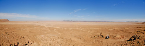
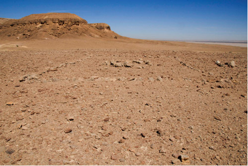
Panoramic view of the plain east of Gebel Khashm et-Tarif. The area could have accommodated many thousands of people. For scale, note the jeep in the lower right.

Mt. Horeb

The first reference to Mt. Sinai in the Bible uses the designation “Horeb” (Ex 3:1). Of the 17 times this name appears in the Old Testament, mainly in Deuteronomy, only once is it given the designation “Mt. Horeb” (Ex 33:6), otherwise it is simply “Horeb.” It is apparent from the many times the term is used in reference to events that occurred at Mt. Sinai (Ex 33:6; Dt 4:10; 5:2; 9:8; 18:16; 29:1; 1 Kgs 8:9), that Horeb is an alternative name for Mt. Sinai and not another mountain or area near Mt. Sinai.

The Mountain of God

“The mountain of God” is the name used for Mt. Sinai in the burning bush account (Ex 3:1), the meeting place of Moses and Aaron (Ex 4:27), the location where Jethro visited Moses (Ex 18:5) and Elijah’s hiding place (1 Kgs 19:8). The fact that the burning bush theophany occurred at Mt. Sinai indicates that it was within grazing distance of Midian, since Moses was “pasturing the flock of Jethro” when he met God at “Horeb, the mountain of God” (Ex 3:1). Midian was located east of the eastern arm of the Red Sea, the modern Gulf of Aqaba or Gulf of Elat. The reference to the meeting place of Moses and Aaron following Moses’ call is very important for locating Mt. Sinai.

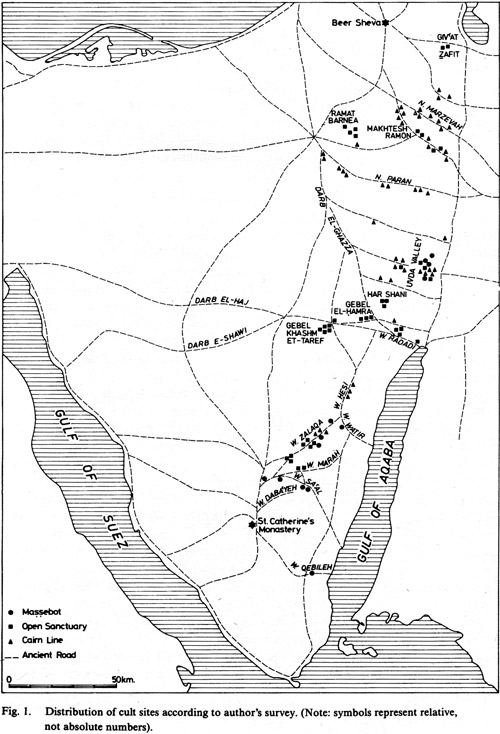
Map of Sinai desert, according to Uzi Azner. From Tel Aviv, 11:116.

When Moses set out from Midian to return to Egypt, he would have taken the most direct route, the Trans-Sinai Highway, which traversed central Sinai from the northern end of the Gulf of Aqaba/Elat to the northern end of the western arm of the Red Sea, the Gulf of Suez. Aaron, whom God had told to meet Moses in the wilderness (Ex 4:27), would have taken the same direct route in travelling from Egypt toward Midian. Therefore, their meeting place, The Mountain of God, must have been located somewhere along this road. Furthermore, in order to be within grazing distance of Midian, it must have been near the eastern end of the road. Gebel Khashm et-Tarif, the mountain visited by an ABR team in 2007, is located in precisely this area, on the Trans-Sinai Highway ca. 22 mi west-northwest of the northern end of the Gulf of Aqaba/Elat (Wood 2007).

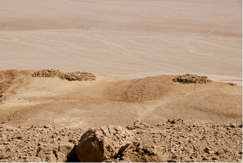
Burial cairns on the summit of Gebel Khashm et-Tarif indicate that the mountain was considered a holy mountain in antiquity.

Mt. Paran

Mt. Sinai is twice referred to as Mt. Paran in the Old Testament. In Moses’ blessing upon Israel prior to his death, he made a clear connection between Mt. Sinai and Mt. Paran:

The Lord came from Sinai, and dawned on them from Seir; He shown forth from Mount Paran, and He came from the midst of ten thousand holy ones; at His right hand there was flashing lightning for them (Dt 33:2; all Scripture quotations are from the NASB unless otherwise indicated).

In his closing prayer, Habakkuk made a similar connection between Mt. Sinai (implied) and Mt. Paran:

God comes from Teman, And the Holy One from Mount Paran. His splendor covers the heavens, And the earth is full of His praise. His radiance is like the sunlight; He has rays flashing from his hand. And there is the hiding of His power (3:3–4).

The name Paran most often occurs in the Old Testament as “Wilderness of Paran” (Gn 21:21; Nm 10:12; 12:16; 13:3, 26). The Wilderness of Paran was the area encompassed by the Wadi Paran and its tributaries, extending from approximately the midpoint of the Arabah Valley between the Dead Sea and the Gulf of Aqaba/Elat, southwest to the Trans-Sinai Highway. That the Trans-Sinai Highway went through the Wilderness of Paran is evident from 1 Kings 11:18. When Hadad, heir to the throne of Edom, was taken to Egypt for safety during David’s reign, his retinue followed the same route Moses took centuries earlier. Starting from Midian, they travelled to Paran then on to Egypt.

The use of Mt. Paran as an alternate name for Mt. Sinai leads to the conclusion that Mt. Sinai should be located in the Wilderness of Paran. Gebel Khashm et-Tarif is located on the Trans-Sinai highway on the southern edge of the Wilderness of Paran.

An example of one of the many stone structures found scattered around the base of Gebel Khashm et-Tarif. These stone structures suggest that a large number of people camped in the vicinity of the mountain in antiquity.

Mt. Seir

Mt. Seir is mentioned 15 times in the Old Testament and Seir 14 times. The most significant reference for our purposes is Deuteronomy 1:2: “It takes eleven days to go from Horeb to Kadesh Barnea by the Mount Seir road” (NIV). There is general agreement among scholars that Kadesh Barnea is located at Ain el-Qudeirat in northern Sinai. Most likely, the Mt. Seir road was a north-south road leading from Kadesh Barnea to Horeb/Mt. Sinai and then on to Mt. Seir. If the route of the Mt. Seir road could be ascertained, the location of Mt. Sinai could be fixed at the intersection of the Mt. Seir road with the Trans-Sinai Highway. Although Kadesh Barnea provides a northern location on the road, where was Mt. Seir, the southern terminus?

Several Biblical passages indicate that Mt. Seir was in the Wilderness of Paran in the vicinity of Mt. Sinai:

Chedorlaomer and the kings that were with him came and defeated…the Horites in their Mount Seir , as far as El-paran, which is by the wilderness (Gn 14:5–6).

Thus dwelt Esau in mount Seir (Gn 36:8, KJV). Esau took his wives from the women of Canaan…also Basemath, Ishmael’s daughter (Gn 36:2–3). He [Ishmael] lived in the wilderness of Paran (Gn 21:21).

The Lord came from Sinai, And dawned on them from Seir; He shone forth from Mount Paran (Dt 33:2).

There is a mountain named Gebel esh-Shaira 55 miles northwest of Elat which Har-El believes is the Mt. Seir of the Old Testament:

The “eleven days’ journey from Horeb by the way of Mount Seir into Kadesh-Barnea‘” (Deut. 1:20)—with Mount Seir identified as Jabal e-Seira, northwest of Eilat—also helps to locate Mount Sinai (1977: 80).

The problem with identifying this mountain as Biblical Mt. Seir is that it is too far west to be considered part of the Wilderness of Paran. But there is another mountain named Gebel esh-Shaira just six miles south-southwest of Gebel Khashm et-Tarif which is within the Wilderness of Paran. It is feasible, therefore, that the Mt. Seir Road went from Kadesh Barnea south past Gebel Khashm et-Tarif to Gebel esh-Shaira. In fact, there is an ancient track that follows that very route. If this reasoning is correct, Gebel Khashm et-Tarif would be at the intersection of the Trans-Sinai Highway and the Mt. Seir Road as required by Exodus 4:27 and Deuteronomy 1:2.

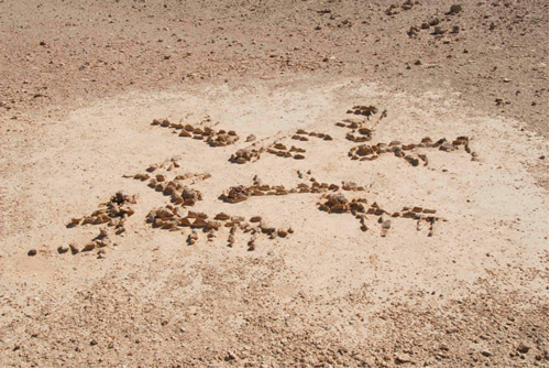
Stone-made animal figurines at the base of Gebel Khashm et-Tarif. Scholars have no explanation for this “desert art” (Avner 1984: 122). Could the figures have been made by people who had a lot of time on their hands?

The Acid Test

There is a way to test our proposed identification of Gebel Khashm et-Tarif as Mt. Sinai. If it fits the time-space conditions set forth in the wilderness itinerary preserved in the Biblical record that would add credibility to the theory. The Israelites arrived at Mt. Sinai “in the third month after the sons of Israel had gone out of the land of Egypt, on that very day” (Ex 19:1). Since they left Egypt in the first month (Nm 33:3), it took them two months, or 60 days, to reach Mt. Sinai. The travel distance from the starting point at Rameses (=Tell el-Daba) to Gebel Khashm et-Tarif is approximately 290 miles. Allowing for Sabbath rest, the Israelites would have travelled 52 of the 60 days of elapsed time. This results in an average rate of travel of 5–6 miles per day, a reasonable rate for a large group of people travelling with animals (Wood 2000).

Deuteronomy 1:2 states that it was an 11-day journey from Mt. Sinai to Kadesh Barnea. We shall assume in this case that the 11 days was the total number of travel days, rather than an elapsed time. The road distance from Gebel Khashm et-Tarif to Ain el-Qudeirat/Kadesh Barnea is about 78 miles. Traveling an average of 7 miles per day, the Israelites could have made the journey in 11 days as required by Deuteronomy 1:2.

Conclusion

The Bible provides a complex matrix of specifications for the location of Mt. Sinai. It must be toward the eastern end of the Trans-Sinai Highway and along the Mt. Seir road. In addition, Mt. Sinai should be found in the Wilderness of Paran a 60-day journey from Rameses and an 11-day journey from Kadesh Barnea. Gebel Khashm et-Tarif is the only site thus far proposed for Mt. Sinai that meets all of these requirements.

Recommended Resource for Further Study

Biblical archaeologists have gathered archaeologist data with painstaking effort and scholarship. Their work validates the accuracy of the Bible. Yet mostly within a single decade, Ron Wyatt sought out and claimed the most amazing Biblical sites and relics. The sensational discoveries claimed by Wyatt number nearly 100 and include such things as the Ark of the Covenant, anchor stones from Noah's Ark, a book of the law written by Moses, and the original Ten Commandments in stone. Also Christ's literal living blood, fences from Noah's farm, the Golden Censer, Goliath's sword, the graves of Korah and friends, the Table of Showbread, and the wheels of Pharaoh's chariots (Standish, pages 7-10). These are only the beginning. It is unfortunate for those who love the Bible that all of these incredible claims are almost certainly fraudulent. A great criticism leveled at Mr. Wyatt has been that his "evidence" has generally been in the form of either photographs or nonconclusive specimens, which may or may not have come from the source he claims. His "findings" have not been given independent confirmation by other researchers with specialized training in the fields of archaeology and related sciences, which Mr. Wyatt (a nurse anesthetist by profession) did not have (he died in 1999). This lack of specific education by itself would not invalidate his findings if they could be supported by others, but they cannot. In this book, the Standish brothers examine the Wyatt claims in-depth, going beyond his videotaped claims. These findings can serve as a benchmark upon which Ron Wyatt's "discoveries" can be more carefully evaluated. In 58 easily-read chapters the Standishs meticulously, painstakingly examine in detail all of Wyatt's claims.

Bibliography

Aharoni, Yohanan
1962 Kadesh-Barnea and Mount Sinai. Pp. 115–82 in God’s Wilderness, by Beno Rothenberg, Yohanan Aharoni and Avia Hashimshoni, trans. from Hebrew by Joseph Witriol. New York: Thomas Nelson & Sons.

Avner, Uzi
1984 Ancient Cult Sites in the Negev and Sinai Deserts. Tel Aviv 11: 115–31.

Har-El, Menashe
1977 The Exodus Route in the Light of Historical-Geographical Research. Ariel 44: 69–84.

Wood, Bryant G.
2000 Beneath the Surface: An Editorial Comment. Bible and Spade 13: 98–99, available at: http://www.biblearchaeology.org/post/2006/05/Thoughts-on-Jebel-al-Lawz-as-the-Location-of-Mount-Sinai.aspx.

2007 In Search of Mt. Sinai. Associates for Biblical Research Electronic Newsletter 7.6: 1–3.

Comments Comment RSS

11/21/2008 7:08 PM #

Reference your article, "What Do Mt. Horeb, The Mountain of God, Mt. Paran and Mt. Seir Have to Do with Mt. Sinai?"

I find it interesting that you take careful note of the scriptural distances and measurements in order to locate Mt. Horeb.  However, to locate any objective, as a navigator will advise you (yes, even a Boy Scout) there must be an initial reference point.  The reference point that is missing is the actual exodus route.

Your assumptions and conclusions are obviously based on a referential assumption that the Red Sea crossing took place in the area of the Suez Canal.  You have applied scriptural specifications upon an assumption based on another assumption; therefore, your conclusion must be reasonable.

Sir, it is good that you observe the scriptures regarding times and distances.  However, you seem to have neglected the specifications for the referenced event upon which everything else depends; that is, the exodus.

The Biblical descriptions of the topography of the exodus route and, specifically, the Red Sea crossing, do not match the topography surrounding the area of the Suez Canal or any terrain in the vicinity.  This Biblical description must be found, FIRST.  Until then you can only arrive as such rather frivolous conclusions as Gebel Khashm et-Tarif being Mt. Horeb.  First, it was the prominent mountain near the tip of the Sinai Peninsula, and now it is the mount.  All based on the same premise, which is based on speculation.

Did I say frivolous conclusion?  And why not?  For example your photos showing the construction of aged animal figurines near the base of the mount with the caption questioning if these could not have been made by people with "too much time on their hands."  Yet none of the Biblical structures mentioned in Exodus seem apparent to anyone: for example, the foundation of the stone altar, the pillars and boundaries.  Also, your observation that there is plenty of land around the mount that could have easily accommodated all of Israel could be said of so many mounts in the region.  Yet, perhaps the most comical aspect of your conclusion is that Gebel Khashm et-Tarif does not appear to be a genuine mountain at all, but a butte with a few burial cairns on top. (Is this mountain unique in that there are burials on top?)

Sir, with all respect, please locate the area of the exodus crossing as described in scripture.  Until then, all else is wild speculation.

Yours most faithfully,
Barry Blake
Barryblake777@hotmail.com

Barry Blake - 11/21/2008 7:08:02 PM

11/21/2008 7:50 PM #

Dear Mr. Blake,

Thanks for contacting ABR about this article.

Based on your comments, we would point you to the following, well-researched articles that discuss some of the matters with which you are concerned. They are posted below for your perusal and consideration. We appreciate your concerns about the article, but the term frivolous is quite unfair, especially in light of the fact that Dr. Wood has been researching this subject for a long time and other articles on this site and in Bible and Spade magazine address many of the issues connected to the Exodus and location of Mount Sinai.

www.biblearchaeology.org/.../...ssing-Part-II.aspx

www.biblearchaeology.org/.../...ossing-Part-I.aspx

www.biblearchaeology.org/.../...h-of-Mt-Sinai.aspx

www.biblearchaeology.org/.../...ct-at-Rameses.aspx

www.biblearchaeology.org/.../...es-at-Rameses.aspx

These articles should help provide a larger contextual study for Dr. Wood's rationale.

Thanks for contacting us and for your interest in the ministry of ABR.

I hope this helps,

Henry Smith

abr - 11/21/2008 7:50:11 PM

12/1/2008 2:05 AM #

WELL I THINK THE ARTICLE IS WONDERFUL AND VERY PROFOUND. THE FACT THE MOUNTAIN Gebel Khashm et-TariF  MOST FITS THE DESCRIPTION OF SINAI IS NOTEWORTHY. MY STUDIES OF SCRIPTURE HAVE REVEALED THAT ONE OFTEN HAS TO ADD A LITTLE IMAGINATION AND FAITH TO THE WRITTEN WORD AND THE FACTS ON THE GROUND TO REACH THE TRUTH.THIS IS WHY I BELIEVE, THE BIBLE WRITERS SUGGEST IN PSALM ONE AND JOSHUA 1:8 THAT ONE SHOULD MEDITATE ON THE WORD BEFORE APPLICATION ( ESPECIALLY JOSHUA 1:8) FOR INSTANCE, JOSEPH'S DREAMS SEEM TO SUGGEST BY THE SUN AND MOON AND ELEVEN STARS BOWING DOWN TO HIS STAR, THAT HIS FATHER, MOTHER AND ELEVEN BROTHERS WOULD BOW TO HIM IN THE FUTURE. HOWEVER, WHEN THE DREAM WAS FULFILLED, HIS MOTHER HAD LONG PASSED AWAY. IT'S EASY FOR AND UNBELIEVER TO SAY THAT THE FULFILMENT WAS INACCURATE; BUT AN UNDERSTANDING OF THE FACT THAT A MARRIED COUPLE ARE 'ONE' COULD LEAD TO THE CONCLUSION THAT JACOB'S SUBMISSION TO JOSEPH IN EGYPT WAS THE SAME AS HIS LATE WIFE BOWING AS WELL. THERE AGAIN IT IS POSIBLE TO ADD BY MEDITATION AND UNDERSTANDING THAT THOUGH JACOB DID NOT BOW LIKE HIS SONS DID IN EGYPT, UNDERSTANDING MAKES SUBMISSION EQUAL TO BOWING.
THE BIBLE DOES NOT ATTEMPT TO SAY ALL AND INDEED HISTORICAL AND ACHEOLOGICAL DATA MAY BE INSUFFICIENT, YET THE INFO. BETWEEN THE LINES RECORDED IN THE BIBLE CAN BE SEEN WITH THE EYES OF FAITH AFTER SOME MEDITATION OR SHOULD I SAY IMAGINATION? THIS I BELIEVE IS WHAT MAKES THE ARTICLE  RELIABLE . THANKS VERY MUCH DR. WOOD.

TONY AYISI - 12/1/2008 2:05:03 AM

12/3/2008 1:48 AM #

Great article! But, correct me if I'm wrong, did not Moses lead the nation of Israel OUT of Egypt...and was not the Sinai peninsula part of Egypt? Is not Jethro from the land of Midian, which is today in Saudi Arabia across the Red Sea?

G. Garcia

Geo Garcia - 12/3/2008 1:48:38 AM

12/3/2008 3:17 PM #

Dear Mr. Garcia,

Thanks for contacting the ministry of ABR. Thanks very much for your questions.

1. The Sinai was not considered part of Egypt proper in ancient times. So, when the Israelites left the land of Goshen, they were outside Egypt proper.

2. Here are two articles about Midian and Saudi Arabia as it pertains to Mount Sinai.

www.biblearchaeology.org/.../...-Saudi-Arabia.aspx

www.biblearchaeology.org/.../...-Saudi-Arabia.aspx

I hope this helps!

Henry Smith

abr - 12/3/2008 3:17:17 PM

3/12/2009 1:28 PM #

Paul identifies the location of Mount Sinai in Arabia (Gal 4:25), in the land of Midian, east of the Gulf of Aqaba.  Larry Williams & Robert Cornuke claim to have stood on Mt. Sinai, Jabal al Lawz near Al Bad. [The Mountain of Moses - L Williams, 1990, Wynwood Press // The Mountain of God - R  Cornuke & D Halbrook - 2000, Broadman & Holman Pub].  Their photos and observations suggest they may have actually found the correct site of Mt. Sinai.  Also, Dr. Lennart Moller suggests the same location using other sources in his book:  The Exodus Case - L Moller, 2002, Scandinavia Pub.   James Montgomery likewise suggests Mt. Sinai lies in the vicinity of the "volcanic harra" of the Midian, east of the Red Sea: Arabia & the Bible - J Montgomery, 1934, Univ of Pennsylvania Press (pp.46-47).

Steve Karpacz - 3/12/2009 1:28:22 PM

3/12/2009 3:23 PM #

Dear Steve,

The Saudi Arabia thesis is unworkable with the Biblical data. Here is another article that deals with the Galatians 4:25 issue, as well as other information. To say that Paul is referring to Arabia 2000 years ago in the same way it is known today is, quite frankly, untenable and unsupportable.

www.biblearchaeology.org/.../...-Saudi-Arabia.aspx

Here are a few more articles dealing with the Exodus Crossing, Exodus Route and Mount Sinai.

www.biblearchaeology.org/.../...ct-at-Rameses.aspx

www.biblearchaeology.org/.../...ossing-Part-I.aspx

www.biblearchaeology.org/.../...ssing-Part-II.aspx

www.biblearchaeology.org/.../...f-Mount-Sinai.aspx

ABR - 3/12/2009 3:23:27 PM

8/18/2009 12:38 PM #

I find it incredible that even though the first person to propose Jebel Hashem El Tarif as the Biblical Mt. Sinai is filmmaker Simcha Jacobovici and to provide most of the proof that you quote above, he's never mentioned in any of your writings. In 2007, you mentioned a "TV documentary" in passing "The Exodus Decoded". But you never bring this up again, nor give it as a reference in any bibliography. Why is this? Just as books do not write themselves, films do not make themselves. Shame on you. The film can be purchased through Amazon.com. It's good that you are backing Jacobovici's conclusions but it's a low thing when you don't give credit where credit is due. Is it because he is also the filmmaker behind "The Lost Tomb of Jesus"? Are you concerned that if he is right about Mt. Sinai, he might also be right about the tomb?

Danielle Di Paola - 8/18/2009 12:38:05 PM

8/19/2009 3:06 AM #

Dear Danielle,

Thanks for writing and for your comments...

Dr. Wood has thoroughly analyzed and debunked almost all of Simcha's pseudo-archaeology in the Exodus Decoded here:

www.biblearchaeology.org/.../...xodus-Decoded.aspx

And, did you not read what Dr. Wood says about acknowledging that Simcha may be correct about et-Tarif:

"In the TV documentary, The Exodus Decoded, first aired in the US in August 2006, the producers suggested that Gebel Khashm et-Tarif, located at the eastern end of the Trans-Sinai Highway (N 29º 40’ 15”, E 34º 37’ 30”), is the location of Mt. Sinai. In March 2007 a small team of ABR researchers spent two weeks in the Sinai to check the feasibility of this theory. Although further research is needed, our preliminary assessment is that the mountain fits the Biblical requirements very well."

The correct identification of et-Tarif by Simcha does not necessarily validate the means by which he arrived at his conclusion, nor does it in any way validate his silly attempt to debunk the Resurrection of Christ. Your argument is a non-sequitur.


Regarding the Lost Tomb of Jesus, it is hagiography of the highest order, and has been thoroughly debunked by Christian and secular scholars alike. See here:

www.biblearchaeology.org/.../...Tomb-Unmasked.aspx

www.biblearchaeology.org/.../...-in-Jerusalem.aspx

And, in the Fall 2008 issue of Bible and Spade, Thinking Clearly about the "Jesus Family Tomb" :

www.biblearchaeology.org/.../product.aspx?id=81

We have no concern whatsoever about the conclusions of the Jesus Tomb video because it is patently and absolutely false. The Resurrection of Jesus as the Son of God is the most certain fact in all history. It is the CENTRAL event of all history. We merely affirm that which is already true, and no amount of human foolishness or arrogance can overturn its absolute reality. We are unworthy of His great mercy, and we proclaim this message to you, so that you may be saved as well. We pray that you will acknowledge it as such, and receive the forgiveness of sins through the death and resurrection of Jesus Christ, who is both Lord and God.

Blessings to you,
Henry Smith

ABR - 8/19/2009 3:06:19 AM

2/7/2010 9:15 AM #

I've done quite a bit of research on this subject and I have found that there are problems with Khashm et-Tarif as the real Mt Sinai. Here are my reasons to doubt this theory:

1. The Khashm et-Tarif area was probably in the Shur Wilderness. The Shur stretched from near Kadesh Barnea to Egypt "as you go toward Assyria," probably refering to the Wilderness Way, a major trade route.

2. Like the traditional Mt Sinai, Jebel Musa, it would be unlikely for Moses to have herded his sheep that far from Midian. The closest area to Midian that has more rainfall and so better forage, are the mountains of southern Edom. Crossing the Arabah to forage his sheep is not logical since the deserts east of the Gulf of Aqaba are just as arid as in Midian.

2. Khashm et-Tarif is very near the Wilderness Way. The Egyptians were likely to be frequently traveling in this area because of the copper mines at Timna. There would be little privacy for what took place at Mt Sinai.

3. There is no reason for the area to be called the Sinai. The Egyptian and Canaanite deities were more prominent there. Sinai is the name of the moon goddess who was not known to be worshipped in the area. The moon god, Sin and moon goddess Sinai (later known as Allah and Allat) were worshipped primarily on the east side of the Gulf of Aqaba from Syria down through Arabia.

4. The Way of Mt Seir which the Israelites traveled from Mt Sinai to Kadesh Barnea was further east and most likely stretched from the Seir Mountains of Edom to the Kadesh Barnea area. It would have been much shorter to have just traveled straight north to Kadesh Barnea from Khashm et-Tarif.

5. None of the archeological finds in the area seem to have any real connection to the Exodus. It is not unusual to find ancient religious structures and artifacts in any of the desert areas south of Israel.

6. The Israelites crossed the Red Sea, went out into the Shur Wilderness for three days, camped at least twice, then camped at the Red Sea, and then went into the Wilderness of Sin, and then on to Sinai (Numbers 33:8-10). This route is logical only if they crossed the Gulf of Suez branch of the Red Sea, traveled across the Sinai Peninsula, and then camped at the Gulf of Aqaba branch of the Red Sea. Khashm et-Tarif would have been passed by on their way to the Red Sea campsite. This clear fact also disqualifies Jebel al-Lawz.

7. The Seir Mountains are well established as being in today’s southern Jordan. Seir is another name the Bible uses for Edom. Moses said God came from Seir, Deborah said God came from Edom, and Habakkuk said that God comes from Teman. All are in southern Jordan. The names Mt Paran and the Paran Wilderness do not necessarily mean they are in the same area. The name Paran means caves. Any mountains with a cave in it (Ezekiel’s cave) could have been called Mt Paran.

8. Mt Sinai could not have been in the Wilderness of Paran because the text says that they set out from the Wilderness of Sinai and the cloud settled down in the Wilderness of Paran (Numbers 10:12). That indicates they were leaving the Wilderness of Sinai, not necessarily Mt Sinai itself, as they came into the Paran Wilderness.  The Sinai and the Wilderness of Paran are described as separate areas.

9. The text says the pillar of fire led them at night as well. Under those circumstances, they may have been able to make better time than 5-6 miles per day, and over broad, flat areas, most certainly would have.

What mountain do I think is Mt Sinai?  I believe it is Jordan’s Jebel Khazali. To find out why you may have to read my book.

Daniel Speck
Boulder, Colorado

Daniel Speck - 2/7/2010 9:15:03 AM

7/23/2010 2:20 PM #

I have my own problems with such a low Mt. Sinai. The Bible gives us a few clues when analyzing the geography of the immediate vicinity of the Mount:

1. According to Exodus 19:2, the people camped in front of the mountain, but, according to Exodus 19:17, Moses had to bring the people out of the camp to get to the lower part of the mountain.

2. You could see the mountain top from ground (Exodus 24:17)

3. Moses could climb up and climb down the mountain, then climb up again and stay up there, then, go down, then write down the Law. (Exodus 19:16-24:4)

4. Moses was invisible or barely visible from the top of the mountain. (Exodus 32:1)

5. Moses could neither see the camp nor hear the sound of the people shouting from the top of the mountain, (Exodus 32:7-18), but the camp is visible from the location where Moses broke the tablets below the mountain. (Exodus 32:19) To elaborate, Joshua arose with Moses, and then Moses went up to the mountain. (Exodus 24:13) No more is said about Joshua until Exodus 32:15-20, when Moses goes down from the mountain, Joshua informs us he is unaware of what is going at the camp. Then, Moses goes near the camp and... you know what happens. Anyway, there appears to be a disconnect between Moses and the people, so that the people could not just yell to Joshua and check if everything was all right.

6. Moses smashed the tablets before the camp. (Deut 9:17)

7. There was a wadi that came down from the mountain into which Moses threw the Gold Dust. (Deut 9:21)

While Moses could not see the plain directly in front if he was standing on the top of Hashm el-Tarif, he would have to be deaf not to hear the people shouting and dancing!

I would choose a South Sinai location, preferably, Jebel Serbal, as Mount Sinai, for Jebel Saniya does not match clue 5, Jebel Musa does not match clue 2, and Jebel Serbal is just the right distance from Ramesses, assuming the Israelites stopped at a campsite for one day, and that they traveled about 7.5 mpd. Jebel Khazali could technically work... if the camp was two miles away from the mountain. Jebel al-Lawz doesn't even pass test 1!

As to ABR's criticisms of the South Sinai position:

"Moreover, it is much too far from Midian (east of the Gulf of Aqaba) for Moses to have been shepherding Jethro's flocks there (Exod. 3:1)."

Not really. A careful glimpse of the area south of Edom shows that the South Sinai was far more fertile than Midian, especially Wadi Feiran. The area around Hashm el-Tarif is noticeably barren, so what would Moses be doing shepherding his flocks there?

"A third difficulty is that Mt. Sinai (also called Mt. Horeb) was located in the territory of Edom (Deut. 33:2, Judges 5:4; Hab. 3:3), which did not extend south of the north shore of the Gulf of Aqaba (Crew 2002)."

As Kenneth Kitchen himself says:"Poetical passages such as Hab 3:3 (with YHWH from Teman and Paran) cannot supersede plain narrative evidence; they are simply florid elaborations of a given theme. Paran is the desert between a southern Mount Sinai and Qadesh-Barnea, standing for both places and all that they imply; Teman is in Edom (round which the Hebrews went), and may be simply here a synonym for the southlands."

"The most serious objection to the traditional location, however, is that it is too far from Kadesh Barnea for the Israelites with their livestock (Exod. 13:38) to have made the journey in 11 days (Deut. 1:2; Wood 2000: 99)."

I would consider Deut 1:2 to simply be a redactorial comment, a simple statement of fact of how long it takes for a tourist to the South Sinai to get there from Kadesh Barnea by camel. Incidentally, it does take 11 days to get to Ain Qudeis by camel from Jebel Serbal.

Now, a response to the wrong claims made in the comments section NOT supported by ABR:

1. Mount Sinai in Midian!

Response: No. Show me a single verse in the Bible supporting the idea Egypt stretched beyond the Pelusiastic. All the bible verses being specific on "out of Egypt" say that when the Israelites left Ramesses, they left Egypt. Shur is before Egypt. 1 Sam 15:7 and 1 Sam 27:8 make no sense if Shur is not in its traditional location. Also, I have found no Bible verse which supports the idea Shur stretched anywhere beyond the area between the Eastern Frontier Canal and the Wadi el-Arish. Genesis 25:18 does not count:

Genesis 25:18
And they dwelt from Havilah unto Shur, that is before Egypt, as thou goest toward Asshur, : and he died in the presence of all his brethren.

The KJV translation for “Asshur” is wrong here, which is why I changed it to “Asshur”. The KJV originally had “Assyria”. The Bible is referring to Asshur Son of Dedan, who, as we can tell by in Gen 25:3 and Num 24:22-24, lived between Dedan (Al Ula) and Midian. Also, the Bible is not saying that Shur is “as thou goest to Asshur”, it is saying that the Ishmaelites are dwelling “as thou goest to Asshur.” It also explicitly says that Shur is before Egypt, and that therefore, the traditional location for Shur, and, accordingly, Jebel al-Lawz is a false Mt. Sinai. If the Lawz advocates want to postulate another, fully imaginary Shur (“wall”), for which there is absolutely no evidence for, fine with me.

I think ABR has refuted the rest of the Jebel al-Lawz nonsense quite well.

E. Harding - 7/23/2010 2:20:16 PM

12/30/2011 10:33 AM #

Galatians says that Mt. Sinai is in Arabia.  Whatever the case, Praise God for preserving his people then and bringing me to my own Mount Sinai's in life where I can see God so clearly.

Penny - 12/30/2011 10:33:09 AM

12/31/2011 1:51 AM #

My thanks to Penny for pointing out Paul's comment in his letter to the Galatians placing Mt. Sinai in Arabia. According to Exodus 13:21, the Lord went before the people of Israel in a pillar of cloud by day and a pillar of fire at night that provided light so they could travel both during the day and after dark. Later on in Ex 19:18, the mountain is described as wrapped in smoke and fire and shaken by violent earthquakes. From a naturalistic point of view, both verses describe an erupting volcano, which the Lord might have used to guide His people. Are the modern Mt Sinai and its environs volcanic in origin? Moses was at Mt Nebo east of the Jordan when he died. If common wisdom in Paul’s day placed Mt. Sinai in Arabia, modern Arabia would seem to be the better place to look for it.

Virgil Soule - 12/31/2011 1:51:07 AM

1/3/2012 1:24 PM #

Mount Sinai is NOT in Saudi Arabia, from the following article, www.biblearchaeology.org/.../...-Saudi-Arabia.aspx

"False Assumption #3: Galatians 4:25 says Mt. Sinai is in Saudi Arabia

The third false assumption is that the Apostle Paul says in Gal. 4:25 that Mt. Sinai was in Saudi Arabia. Cornuke plainly states this when he says,

    The apostle Paul, under the inspiration of the Holy Spirit, informs us that Mount Sinai is in Saudi Arabia. Not Egypt! (Cornuke and Halbrook 2000: 171).

The Bible says nothing of the sort. Granted, the Holy Spirit could have predicted the Kingdom of Saudi Arabia long before it came on the world scene. After all, He predicted Cyrus by name 210 years before he became king of Persia (Isa. 44:28; 45:1; Antiquities of the Jews 11: 5; LCL 6: 315). Yet all the Bible says is that Mount Sinai is in Arabia.

Moses never uses the word “Arab” or “Arabia” at the time he wrote the Pentateuch. The words appear later in the Bible (I Kings 10:15; II Chron. 9:14; 17:11; 21:16; 22:1; 26:7; Neh. 2:19; 4:7; 6:1; Isa. 13:20; 21:13; Jer. 3:2; 25:24; Ezek. 27:21). So the Apostle Paul does not have a Mosaic use of the word “Arabia” in mind when he uses the word in Gal. 4:25 because “Arabia” did not exist in Moses’ day.

The Galatians 4:25 reference might indeed support the view that Mount Sinai was in Saudi Arabia if the Apostle Paul was looking at a 1990 Rand McNally Atlas. However, it would not be true if he was looking at a First Century AD Roman road map. Although no actual maps of Roman Arabia exist from this period, we do possess the accounts of the contemporary travelers such as Strabo, a Greek from Pontus (64 BC to ca. AD 25). He describes the borders of Arabia as having its eastern border at the Persian Gulf and its western border at the East Side of the Nile River. This means that Strabo understood the entire Arabian Peninsula and the Sinai Peninsula to be included in First Century Arabia (Geography 16:4:2; 17:1:21,24-26,30,31; LCL VII: 309; VIII: 71-79, 85-87).

The word “Arab” first appears in an extra-Biblical inscription from a monolith found at Kurkh from the time of Shalmaneser III (853 BC). Throughout the Assyrian period, various Assyrian kings describe the activities of the Arabs, or desert nomads.

The first time the word “Arabia” is used as a term for a designated geographical area is in the mid-fifth century BC by the famous Greek historian and traveler, Herodotus (born ca. 484 BC). He traveled to Egypt and wrote about his trip in his book, The Persian Wars. In his monumental work on ancient Arabs, Dr. Israel Eph’al of Tel Aviv University, points out that

    Herodotus … calls the entire region east of the Nile and the Pelusian Branch, from the Mediterranean to the Red Sea, "Arabia", and its population "Arabs" (2: 8, 15, 19, 30, 75, 124, 158) (Eph’al 1982: 193).

“Now in Arabia, not far from Egypt, there is a gulf of the sea entering in from the sea called Red [the Gulf of Suez], of which the length and narrowness is such as I shalI show.” Herodotus, The Persian Wars 2:11; LCL I: 285,287.

Moreover, in the mid-third century BC, 72 Jewish scholars translated the Hebrew Bible into Greek (known as the Septuagint) and followed the contemporary use of the word “Arabia” when they referred to Goshen as “Goshen of Arabia” (Gen. 45:10; 46:34). While Goshen is clearly part of Egypt (Gen. 37:6, 27; Ex. 9:26), the translator imposed the third century BC geographical reality on their translation.

On Egeria’s pilgrimage to the Holy Land, she visited Mt. Sinai (Jebel Musa) and also the Land of Goshen (Wilkinson 1981:91-103). In Goshen, she stayed at Clysma, a “city of Arabia” (Wilkinson 1981:100). She wrote, “It gets its name from the region, which is called "the land of Arabia, the land of Goshen," a region which, while it is part of Egypt, is a great deal better than any of the rest” (1981:100,101). Egeria followed the Septuagint reading of Gen. 46:34 in her description of Goshen being in the Land of Arabia.

Therefore, when the Apostle Paul says that Mt. Sinai is in Arabia, he is using the First century AD understanding of the word. He would be perfectly correct in placing Mt. Sinai in the Sinai Peninsula because the Sinai Peninsula was part of Arabia in his day.

In conjunction with Galatians 4:25, three other verses have been used to demonstrate that Mt. Sinai was outside the Sinai Peninsula: Deuteronomy 33:2; Judges 5:4; and Habakkuk 3:3. It is stated that Seir, Mt. Paran and Teman are located in present day Jordan or even Saudi Arabia (Heiser 1998; Cross 1998).

Most scholars put the territory of Edom in the Transjordanian mountains to the east of the Aravah and northeast of the Gulf of Akaba. A careful examination of the Scriptures places it also on the west side of the Aravah (Num. 34: 3; Josh. 15:1). The area, called today the Central Negev Highlands, from the Wilderness of Zin and Kadesh Barnea, south to Eilat was also Edomite territory (Crew 1981: 121-151; Rasmussen 1989: 91; Meshel 2000: 104). If this were the case, the locations of Seir, Mt. Paran and Teman could be moved back into the Central Negev Highlands and northeast Sinai. A case can be made for Mt. Paran being in the area of Kadesh Barnea, known today as Ein Qudeirat (Num. 13: 26). Mt. Seir could be identified with the Jebel-es-Se’ira, 45 km to the west of Eilat and west of the Kadesh Barnea Eilat road (Har-el 1983: 338). Teman would be located in the area of Kuntillet ‘Ajrud where the inscriptions with the name “Yahweh of Teman” were found (Meshel 1993). If these identifications are accepted, then these passages (Deut. 33:2; Judges 5:4; Habakkuk 3:3) refer to the Lord leading the Children of Israel by the pillar of fire through the northeastern part of the Sinai Peninsula for 40 years. "

Galatians 4:25 does not teach that Mt. Sinai is in Arabia.

Blessings,
ABR Staff

ABR - 1/3/2012 1:24:21 PM

1/11/2012 10:39 AM #

    I enjoyed reading some of the comments and got some nuggets from them. You said your proposed site is the “only one” “that meets all of the Biblical requirements for Mt. Sinai” Some of the comments showed that it did not!
       There are at least nine different crossing places (plus variations) of the Red Sea/Yam Suf crossing and someone has number over twenty mountains for Mount Sinai. I like biblical archaeology but we have more possibilities today not fewer and more confusion. The nine different sea crossings cause not only the four places names of Exodus 14:2 to be place in different locations at each of the propose crossing sites (in some cases hundreds of miles apart) but also the encampments coming up to an following the sea crossing. Their guessing! Most of the encampments given in the Bible are placed on maps today not because they have found the site, but because they need it to be somewhere in that vicinity. One can read both scholars and novices declaring there can be “no doubt” on the location of their site, even though each has his site in a totally different location…. It is embarrassing! Unbelievers poke fun at this!
There is some information being left out of the equation. Some is from Jewish history, and some traditions, can they do any worst than we are today? (Quotations that are italicize, bold print or underline reflects my emphasis)

Some info.
1) There were two Mount Seirs! It was brought out that Mount Sier was important in the article above, but if there were two mountians named this, then maybe we should be looking for the other Mount Sier and not be tied to the traditional one. Deuteronomy 2:1 says, “we compassed mount Seir many days.” Israel was waiting for their 40 years to be up, but when their time was finished at this Mount Seir, they were given new orders. “Ye have compassed this mountain long enough: turn you northward.” (Deuteronomy 2:3) Then the very next verse (v4) said, “And command thou the people, saying, Ye are to pass through the coast of your brethren the children of Esau, which dwell in Seir.” But for several years they had already been at “mount Seir” (verse-1) and now they are going to another Seir, which is also called “mount Seir” (verse 5).

2) Arabia of Paul’s day was not only in Saudi Arabia and the Sinai Peninsula but also in the Eastern Desert of Egypt. The classical writers have “Arabia” a being east of the Nile Valely, this included the Eastern Desrt. (Herodotus. History, Book II. 17. & Strabo. Geography, Book XVII, 30) Even today most maps name Egypt’s Eastern Desert the “Arabian Desert”!

3) Josephus has the Midains that Moses went to on the African side of the Red Sea (Eastern Desert of Egytp)! This would not work with your site and the other proposed sites, nor would Josephus’s starting place for the Exodus, and is the reason he is seldom quoted in these two areas! “The sons of Madiau were Ephas, and Ophren, and Anoch, and Ebidas, and Eldas. Now, for all these sons and grandsons, Abraham contrived to settle them in colonies; and they took possession of Troglodytis, and the country of Arabia the Happy, as far as it reaches to the Red Sea.” (Josephus. Antiquities, I, 15, 1, that would have Midian on both sides of the Red Sea) Josephus also said when giving the account of Moses meeting the daughters of Jethro (the priest of Midian, Exodus 3:1) said, “These virgins, who took care of their father’s flocks, which sort of work it was customary and very familiar for women to do in the country of the Troglodytes…” (Josephus. Antiquities II, 11, 2) The name Troglodytes means “cave goers” or “cave dwellers,” and many people groups at different times lived in caves, but the “country” of the Troglodytes was in the Eastern Desert of Egypt! (There are also a couple of Mount Seirs in the Eastern Desert of Egypt.)

Diodorus (Greek historian, first century B.C., Book III, 15, 38-39), Pliny the Elder (Roman author, first century, Natural History, book VI) and Strabo (Greek geographer, 63 B.C. to 24 A.D., XVI, 4, 4) not only have the “country” of Troglodytes on the African, or on the west side of the Red Sea (Eastern Desert), but as far north as the head of the Gulf of Suez. So, when Josephus gives the account of Moses meeting the daughters of Jethro the priest of Midian, which he said was “in the country of the Troglodytes…” he and the classical writers (in whose time he wrote) were talking about the Eastern Desert of Egypt.

Pliny the Elder (Roman author, 78 A.D.) also said of the Troglodytes that “Troglodytice comes next, called in former times Midoe…” (Pliny. Natural History, book VI, Chapter 34.) Josephus, writing in the Greek language, spells the name of Madian as “Madiau” (Antiquities I, 15, 1), Pliny, writing in Latin, calls the ancestors of the Troglodytes “Midoe”. (Midian is spelled Madian in the New Testament, Acts 7:29)

4) Josephus (first century, Antiquities, II, 12. 1) and Philo (first century, On The Life Of Moses, 2:70) said Mount Sinai was the tallest mountin in the area and very hard to climb. Though many know that they said this it is not mentioned by those with hills and bluffs. In the book Legends of the Jews, there is a conversation that takes place between mountains who are arguing over which one should be chosen. But the biggest mountains were rejected because they were too “proud”, and so the honor went to Mount Sinai, because it was said to be the smallest of mountains and therefore more “humble.” At any rate, Josephus and Philo did not get their information from talking mountains. What Josephus and Philo said will probably be considered only an oral tradition they had heard, but they both were alive during the second temple at Jerusalem, which may have had other books that are no longer available (Josephus in his writings quotes people whose writings no longer exist.) Then again Josephus and Philo were not “Biblical archaeologists” so what do they know.  

Garry Matheny - 1/11/2012 10:39:39 AM

2/9/2012 11:54 AM #

I always appreciate harsh criticism and also encouraging comments. Both because in my opinion the harsh ones can keep the researcher humble, and other ones to encourage the researcher to continue his good job. I in particular really appreciate the fact that all this information is there so that I can get at last an idea of what the Bible is talking about when reading about the Exodus and I always appreciate the fact that there is people that take the time to do this kind of research. So my respects to you. Please don’t get discouraged and keep post this kind of interesting information.

Rebecc Garcia - 2/9/2012 11:54:41 AM

2/9/2012 11:50 PM #

I'm neither a scholar nor archeologist, BUT the only body of water worth parting and capable of drowning an Egyptian army on the way to "Mt. Sinai" is the Gulf of Aqaba as I look at your map? I yield to those more knowledgeable.

Geo - 2/9/2012 11:50:13 PM

10/27/2012 5:07 PM #


Dear Sir

        Upon reflection I write to say I am sorry because some of what I wrote before (1/11/2012 10:39 AM) was "harsh criticism".
        I respect your work there at ABR, and thank God for you being there. Also for the opportunity to get my view across.
Keep up the good work!
Garry Matheny

Garry Matheny - 10/27/2012 5:07:01 PM

6/26/2013 3:36 PM #

This is an interesting article to find as I do my own studies into the first books of Deut. I'm not a bible scholar, but am a scientist and engineer in other fields.

My comment is primarily about Mount Seir. In reply to another comment above that states:

"1) There were two Mount Seirs! It was brought out that Mount Sier was important in the article above, but if there were two mountians named this, then maybe we should be looking for the other Mount Sier and not be tied to the traditional one. Deuteronomy 2:1 says, “we compassed mount Seir many days.” Israel was waiting for their 40 years to be up, but when their time was finished at this Mount Seir, they were given new orders. “Ye have compassed this mountain long enough: turn you northward.” (Deuteronomy 2:3) Then the very next verse (v4) said, “And command thou the people, saying, Ye are to pass through the coast of your brethren the children of Esau, which dwell in Seir.” But for several years they had already been at “mount Seir” (verse-1) and now they are going to another Seir, which is also called “mount Seir” (verse 5)."

After lots of playing around with google earth and trying to resolve the facts that Kadesh seems to be well located (Ain el-Qudeirat), and quite far away from the area of Petra, which seems to have a lot of historical evidence pointing to that area being known as Seir, I've stumbled on a theory about the above verses (Deut 2:1-3).

The theory I want to put forward is that Seir appears to be used for the mountains on EITHER side of the Arabah valley. This seems to fit the above verses and the propsed locations of Kadesh-Barnea and "Mount Seir" (Petra) very well.

1. The discussion about Seir in the vicinity of Kadesh barnea talk about a "Mount Seir road". Deut 1:2 "(It takes eleven days to go from Horeb to Kadesh Barnea by the Mount Seir road.)", and Deut 2:1 "Then we turned back and set out toward the wilderness along the route to the Red Sea, as the LORD had directed me. For a long time we made our way around the hill country of Seir. "

Going by way of a road over a single mountain makes no sense. If you're not going to the top of a mountain, you're going to walk around it. The fact that Mount Seir has a road that connects Kadesh to the Red Sea means we're likely talking about a road along the highlands above the Arabah.

From Kadesh to the Red Sea you have two options. The first is to first go north around the mountain enclosing the Ain el-Qudeirat valley, and then turn south going through the lowland desert. The second would be to ascend to the highlands to the east and follow them down to Aqaba (essentially following the course of the current Taba Rafah road, with departs the highlands at Har Karkom). If this route is the biblical "Mount Seir road", then it will indicate that highlands to the west of the Arabah use the name "Mount Seir" or just "Seir".

This is something that I've yet to find anyone else claim.

2. Others seem to associate Kadesh directly with Petra, but this makes no sense in light of Deut 2:1-3. They would head due south, only to turn 180 degrees and retrace their footsteps.

However, if Seir is used for the highlands on EITHER side of the Arabah, then it makes sense. They would head southeast to Aqaba along the Mt Seir road, and then take the same road north to the area of Petra and eventually to Jericho.

3. Moab seems to have occupied highlands on both side of the Arabah at this time, and the text of Deut seems to indicate that the Israelites are doing their best to avoid the Edomites. This would mean that would take these highland roads rather than the probably easier road directly through the Arabah.

Deut 2:8 states: "So we went on past our relatives the descendants of Esau, who live in Seir. We turned from the Arabah road, which comes up from Elath and Ezion Geber, and traveled along the desert road of Moab.".

This has them travelling north from Aqaba on "the desert road of Moab". Since it's not in the Arabah road, it must ascend to the highlands to the east. I'm guessing they took the route of the current highway 15 in Jordan, through the wide mountain pass. It seems to me this pass would be a very key place for a dig looking for evidence of the israelites passing through. Other passes to the north may have also been possible, however, if they joined the Arabah road before they got to Aqaba.


So, as for Horeb, using this above outlined route, this seems to point to Har Karkom as Mt Sinai. It is located 39 miles via the current desert routes from Kadesh Barnea, which should be easily doable with livestock in 11 days.

The only difficulty for this location is whether it makes sense for Moses to have been grazing his flock there from Midian. I think Har Karkom is about 50 miles outside of Midian. Still, it makes way more sense than the southern tip of the Sinai peninsula.

JT - 6/26/2013 3:36:57 PM

8/13/2013 4:08 PM #

It is the glory of God to conceal a thing: but the honour of kings is to search out a matter.  Proverbs 25:2
For this Agar is mount Sinai in Arabia and answerth to Jerusalem which now is and is in bodage with her children. Gal 4:25
Now Moses kept the flock of Jethro his father in law, the priest of Midian: and he led the flock to the backside of the desert, and came to the mountain of God, [even] to Horeb.  And the angel of the LORD appeared unto him in a flame of fire out of the midst of a bush: and he looked, and, behold, the bush burned with fire, and the bush [was] not consumed. Exodus 3:1-2
The Bible seems pretty clear where Mt. Sinai is located... Not on the Sinai Pen...  it's in Arabia...  where Midian is located...  why is this article pointing to an area that is not according to scripture??  

TJ - 8/13/2013 4:08:43 PM

8/13/2013 4:24 PM #

Dear TJ, re: 8/13/13 post

All the articles here on the ABR website which debunk the Saudi Arabia theory can be found here: http://www.biblearchaeology.org/tag/sinai.aspx

Please read the articles very carefully. When you do, you will find the Saudi Arabia theory has no basis.

Thanks for your interest in the ABR ministry.

Sincerely,
Henry Smith
ABR Staff

ABR - 8/13/2013 4:24:05 PM

8/14/2013 3:34 PM #

All very interesting but I have to say I'm quite disappointed with the theory of the latest "Mt Sinai".  I'm also regularly disappointed at the - frankly - stupidity of a number of your correspondents especially those who keep banging on about Paul saying it was in "Arabia".  It seems that there are a large number of people who have bought into the bogus Gulf of Aqaba and Saudi Arabian theory of the Exodus which has been fully demonstrated to have absolutely no basis in fact.

A number of people both academics and amateurs, showing their lack of scriptural and historical knowledge, taking snippets of information without building up a full understanding, simply talk utter nonsense about these subjects.  That may be a harsh comment, but it is true.

A comprehensive overview of what the bible says about the Israelites journeys etc, combined with a good background knowledge, clearly shows that the traditional Mt Sinai is indeed the actual location of what it is purported to be.

Somebody demonstrate to me, based on facts and not pure unscientific conjecture that the case is otherwise and we will have something interesting to read on the matter.

Keep up the good work ABR!  Most of the stuff on your site I find to be well researched and very helpful.  And largely accurate.

l gould - 8/14/2013 3:34:02 PM

Research RSS Feed

AddThis Feed Button

Recent Articles

In this article we will discuss why the decree of Daniel 9:25 must be identified with one issued by the...
II. Analysis and Discussion 3. Liber Biblicarum Antiquitatum 4. Augustine’s Renegade Scribe Theory 5....
II. Analysis and Discussion 2. Straw Men and Ad Hominems
II. Analysis and Discussion 1. The Rabbinic Deflation of the MT’s Primeval Chronology
Associates for Biblical Research
  • PO Box 144, Akron, PA 17501
  • Phone: +1 717-859-3443
  • Toll Free: 1-800-430-0008
Friend ABR on Facebook.com Join us on Twitter Join us on Twitter