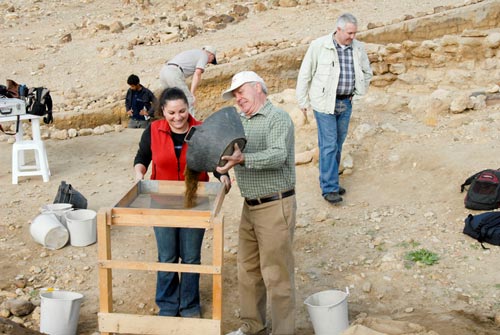
Modern Crime Scene Investigation (CSI) carefully observes, measures, photographs and analyzes contemporary crime scenes in an attempt to reconstruct what happened at that location in the recent past. Archaeological excavations take the same multidisciplinary approach to gathering evidence at an ancient site1. Starting with the observable facts of the site’s natural geographical, topographical and environmental situation, archaeology ultimately attempts to identify each stratum of occupation and human activity, usually by digging a series of scientifically controlled excavation squares. The result is a proposed reconstruction of what transpired at that location during every period of activity at the site. With the addition of ancient written texts, including the Bible, researchers can often provide evidence as amazingly technical and precise as their modern CSI counterparts.
Tall el-Hammam Excavation Project (TeHEP) and Archaeological Site Investigation (ASI)
The Tall el-Hammam2 Excavation Project (TeHEP) is a joint scientific project between Trinity Southwest University’s College of Archaeology & Biblical History (Albuquerque, New Mexico, USA) and the Department of Antiquities of the Hashemite Kingdom of Jordan.3 TeHEP is a multi-year study focusing on the relationship of this immense and strategically-located site within its ancient socio-cultural, economic and political context.
Typical of archaeological research, our own “ASI” (Archaeological Site Investigation) centers on a large ancient city, called today Tall el-Hammam in the southern Jordan River Valley, about 9 miles northeast of the Dead Sea. Archaeological evidence indicates it represents the largest Bronze Age site in the whole region (and possibly in all of Jordan). The tall proper (including both upper and lower) spreads over almost 90 acres, all apparently within the ancient city’s fortifications. Situated in a 100+ acre fertile triangular area against the foothills of the Jordanian plateau to the east, the site is bounded by almost perennial wadis to the north and south, with their confluence in the west. Surveys and excavations suggest a general occupational footprint throughout most of this area from as far back as the Chalcolithic Period through the Middle Bronze Age (some 1,500 years). Significant later occupation on many parts of the site has also been identified during the late Iron Age and Roman periods.
Tall el-Hammam’s geographical location, archaeological remains and massive size suggest it was an active participant in much of biblical history – Old and New Testaments. Precisely what it was named during each period is still under discussion, but the possibilities can be summarized as following (I have outlined the biblical connections in an earlier article4). It was a major city from earliest times and may be one of the oldest cities mentioned in the Bible, in the Table of Nations (Gn 10). It is TeHEP's working hypothesis that Tall el-Hammam was Sodom from those earliest days to the time of Abraham, well over 1,500 years. After its Middle Bronze Age destruction, and with no evidence of occupation for over 500 years, it may have been the site of Abel Shittim (“meadow of the acacia trees”) at the time of Moses. During the Iron Age, a city was built on the upper tall, and it is a reasonable candidate to be the capital of Solomon’s twelfth administrative district – within eyesight of the Mount of Olives at Jerusalem, Solomon’s capital. In New Testament times, a new city arose around the base of the talls and may have the eastern extension of Abila or even Livias (Julias), the capital of King Herod Antipas’ Perea. Finally, Tall el-Hammam may be one of the unnamed sites on the famous Madaba map. Admittedly, this one site fitting every one of these identifications seems unlikely, but it must be considered as a reasonable candidate for each at this point.
Whatever the precise biblical connections turn out to be, it is quite apparent that ancient Tall el-Hammam was a significant Bronze Age city-state. It likely controlled as much as 125 sq miles of territory, stretching from the hills in the east and south while bordering the Dead Sea to the south and the Jordan River to the west. From the western acropolis of the upper city, where a Bronze Age palace complex was located, the kings who ruled from Tall el-Hammam had direct line-of-sight contact with virtually all their domain.
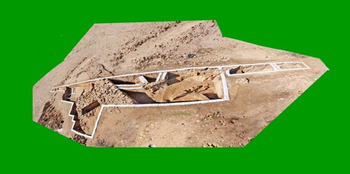
After Season Five, the 66-yard long Tall el-Hammam Trench LA.28
In the previous four seasons5 we were able to identify elements of the city’s defensive system from the Early Bronze, Middle Bronze and Iron Ages, circling the upper tall. Within the city’s defenses we also excavated monumental structures (palaces) and common houses from each of these periods, as well. This year’s major focus was on clarifying the city’s fortification around the lower tall, centering on Trench LA.28. I am summarizing from our fifth year Season Activity Report to the Department of Antiquities of Jordan (Collins et al 2010), especially evidence from that 10-square, 66-yard long trench.
The Early Bronze Age Defensive Fortification System
A very consistent line of stone blocks clearly representing the inner face of a city wall could be seen on the surface along the southern side of the lower tall. Scholars have long assumed it was the Early Bronze city wall and we did likewise. Last season we excavated this inner face to below its base, about 5ft deep. This season we were having trouble finding its outer face, until we realized that we were working with the remains of two different walls from two different periods.
At the conclusion of this year’s excavation, we could identify an approximately 13ft thick Middle Bronze city wall built over and inside an earlier Early Bronze city wall which turned out to be 17ft thick. It was constructed with a base of stone boulders, five or six courses high, and up to four courses of mudbricks above that – still standing to over 6ft. The absolutely stunning thing is that it was all sitting just below the surface and had been there just like that for almost 4,000 years!
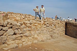
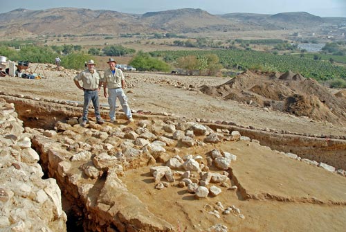
TeHEP dig director, Dr. Steve Collins, and the author standing on top of what remains of the Early Bronze city wall, with the Early Bronze roadway in the foreground.
Carefully ASI excavating at the base of this Early Bronze wall brought even greater insights about the ancient city. The first thing we recognized was a hard-packed mud road surface carefully constructed against the wall’s outer stone foundation and gently sloping away for at least 16ft. It appeared they were both constructed and in use at the same time.
Further investigation of the Early Bronze wall indicated it had been constructed in two distinct building phases. Built in conjunction with the road surface during Early Bronze 2, it consisted of inner and outer wall faces of stone boulders and the space between filled with a mudbrick core. The entire wall (17ft thick) was topped by a mudbrick superstructure.
Evidently that wall was destroyed and rebuilt later in the Early Bronze Age. This rebuild started just above the original stone foundation which the builders leveled with one or two courses of mudbricks and four or five courses of stone. So this rebuild was the top of the wall we found still standing. The roadway continued to be refurbished and re-used for hundreds of years.
This was a critical point of clarification for us. Last season, we were unsettled by the size of the stone boulders we found in that inner face wall’s construction. It “felt” more like typical Middle Bronze boulder-and-chink construction than Early Bronze. As it turned out, this wasn’t the EB wall we thought it was (but more on this wall line later).
In Trench LA.28, the TeHEP team is sifting excavated dirt in the foreground (above) with the ancient mudbrick superstructure of the city wall in the upper right. See a close up of those mudbricks (below), still standing just below the present ground surface.
The Early Bronze Age City Gate
Trench LA.28, where we excavated the city wall, was cut perpendicular (north/south) to the wall line. This trench of typical archaeological squares was the standard 5m (16ft) in width. We chose this particular location because we could see that original city wall inner face on the surface, along with stone house foundations inside the city and additional parallel stone wall lines on the outside. It seemed like a good place to ASI a number of interesting features, but we had no idea just how significant this very location along the city wall would be.
As if the finds already described weren’t enough – believe it or not – along the east edge of our trench we also found a gate in the Early Bronze city wall! Not substantial in size, just over 4ft wide and straight through the wall, it was clearly constructed in conjunction with the original Early Bronze wall and then reused in the later Early Bronze period. That even helps understand the hard-packed mud road area on the outside. This would have been a well used location for people to congregate and maybe even a bit of a market place.
Later, the outer face of the gate opening was blocked with a solid stone wall line and the gate passageway was backfilled with mudbrick material. We are guessing this may have been done in the Intermediate Bronze Age or Middle Bronze 1 periods, but it will take coring the blocking wall in the future to be sure.
While this gate was not large in size or monumental in construction, it was an important part of the Early Bronze city fortification system. It is reasonable to assume this was not a main city gate and there may have been as many as four or five such gates in the city’s defensive wall. While the later Intermediate or Middle Bronze 1 blocking of this gate indicates it was no longer in use, the wall line and the outer street against the wall continued to be used.
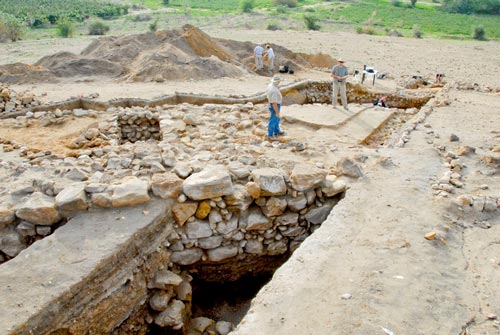
TeHEP dig director, Dr. Steve Collins, and the author standing on top of what remains of the Early Bronze city wall. Notice the wall’s full width and the Early Bronze gateway behind and to the left of Collins. “Dirt” in the foreground is actually the base of the wall’s mudbrick superstructure. Remains of the Middle Bronze city wall are seen on the far left.
Middle Bronze Age Fortification System
While we didn’t really see it as we were digging everything out (even CSI misses some things the first time around!), after we had excavated the 5ft of debris from present ground level down to the roadway outside of the city wall, we had another major surprise.
Very clearly in the western side of the excavation square (in ASI we call the side of the square a “balk”) you could see that the roadway was deliberately covered by different layers of fill all the way to the present ground surface. This filling was literally piles of various kinds of materials—all engineered-fill with consistent pottery from every period, beginning with Chalcolithic right through to Middle Bronze. In ASI research, the latest dated pottery is the earliest date the material could have been put there. It became clear to us that Middle Bronze builders built their own city wall by first filling in the road area up to what was left of the Early Bronze city wall and then constructed their own defenses above.
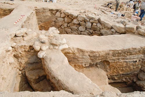
Trench LA.28 showing the inside face of the Middle Bronze stone city wall. The later Early Bronze city wall is just behind it and the two actually look blended together from this angle. But see the Early Bronze city gate with stone blocking along the outer face, center left. The mounds of dirt at the top of the photo are our dirt dump from Trench LA.28.
Further ASI support to this interpretation came when we traced a hard-packed mud street inside the city which abutted the inside face of the Middle Bronze stone city wall. This street sealed against a well-dated Middle Bronze stone house foundation on one side and against the facing boulders of the city wall on the other. All three were apparently contemporaneous in both construction and usage.
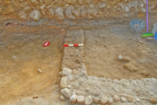
The stone pile, just beneath and to the right of the red/white meter stick, is the remains of a Middle Bronze house foundation. The wall of large stones going deep into the square on the right is the inner face of the Middle Bronze city wall. The 3ft wide dirt walkway between them is all that is left of the Middle Bronze city street connecting the two stone structures.
So now we had the Middle Bronze stone house foundations, an inner roadway and the inside face of the Middle Bronze city wall. These were wonderful finds – but the season wasn’t over and we just kept extending our excavation trench of squares further outside (south of) the city wall and past the hard-packed outer road. In the end, we uncovered the full width of the entire Middle Bronze fortification system – and it was far more extensive than we ever dreamed.
It will sound a bit technical (but it is good ASI stuff!) and I want you to get a feel for the vastness of the Middle Bronze city fortifications we found at Tall el-Hammam this season. From inside (north) to the outside (south) it consisted of the following elements:
a) The 13ft thick stone boulder constructed city wall (originally topped by a mudbrick superstructure of which we found nothing) built over engineered fill, placing the bottom Middle Bronze stone course at the same level as the remaining top course of the former Early Bronze city wall;
b) The entire 17ft thick Early Bronze city wall and 16ft wide outer road were also covered with that engineered fill. This fill extended to a parallel 4ft thick stone stabilizer wall;
c) Laid mudbricks, representing the Middle Bronze exterior defensive rampart, extend from that wall further south to another parallel stone stabilizer wall; (d) and then more mudbrick and another wall still further to the south; (e) and then bits of mudbrick were found out to the edge of a bedrock scarp.
All this laid mudbrick created a sloping defensive rampart (much of which was built above the purposely deposited fill) extending out from the city wall. Taken together, these features (including the Middle Bronze stone city wall) extend over 100ft. That would be a 100ft+ defensive fortification close to 4,000 years old, and most of it started appearing just beneath the present ground surface! It is still hard for me to imagine that it has been sitting there all this time and no one had any idea. The features of our Middle Bronze fortification system should offer important new data for understanding Middle Bronze Age defenses elsewhere.
Chalcolithic Houses
We reached bedrock a bit over a foot below the Early Bronze roadway. Sitting on the bedrock were remnants of what appear to be two Chalcolithic broadhouses. We excavated the foundation trench for one of them and it was cut into the rather soft bedrock, containing only Chalcolithic sherds. It appears to also have been refurbished later, in Early Bronze 1. Next year we will completely excavate inside both houses using micro techniques to understand what activities had taken place there over 5,000 years ago.
Chalcolithic broadhouse stone foundation with Early Bronze 1 rebuild above. This house was covered by the later Early Bronze roadway outside the city wall and gate.
Dig Director Collins noted that we had evidence of occupation in this area, for all intents and purpose, continuously from the Chalcolithc/Early Bronze 1 houses – with no evidence of erosion overlaying them – right into the later Early Bronze road and city wall phase. Chalcolithic and Early Bronze 1 settlements are known elsewhere to not typically be fortified and city fortifications are known to have generally begun in Early Bronze 2. But the virtual no significant lapse in time between them here at Hammam was a bit surprising.
The original city wall appears to have been constructed above part of at least one of the houses. But why did the site’s inhabitants decide it was necessary to build the wall in the first place? It also begs the question – who could command the power, authority and resources to undertake such a monumental task. While this phenomenon occurred at enough sites during this time period that scholars have already recognized a trend, we can only speculate about the people or the plans here at Tall el-Hammam.
Continuous Occupation – Chalcolithic to Middle Bronze Age
Putting all this good ASI evidence together from Trench LA.28 suggests no hint of any occupational break or any evidence of erosion overlaying any feature in this part of Tall el-Hammam from the Chalcolithic to Middle Bronze Age. Fill dumped in top of the Chalcolithic/Early Bronze 1 houses leveled that area for construction of the Early Bronze 2 city wall and roadway. Above the roadway, piles of fill again leveled the area as a base for the Middle Bronze city wall. Even though there is evidence for significant destruction during a couple of periods (seen along Trench LA.28 inside the city), the inhabitants of Tall el-Hammam seemed to regroup quickly and rebuild all through the Bronze Age.
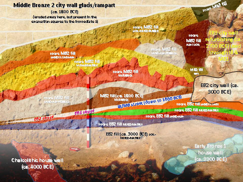
A Thumbnail ‘History’ of Tall el-Hammam. The west balk of Trench LA.28P on the lower tall at Tall el-Hammam indicating continuous occupation at the site from the Chalcolithic to Middle Bronze Age.
So, while the site continued to be occupied throughout a couple of millennia, occupational changes still occurred and are evident in the archaeological record. The changes are sometimes as simple as a decision to start new construction or renovate something old – such as the decision to build the first city wall in the Early Bronze Age. But, at least three periods of occupation at Bronze Age Tall el-Hammam appeared to end in destruction, based on the evidence. The cause of those destructions is unclear – possibly natural disaster, human error or even war. All we know for sure, at this point, is that it happened and the city was quickly rebuilt again each time – until the last one.
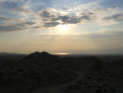
Sunset at Tall el-Hammam. The acropolis of the Middle Bronze Age palace on the upper tall is silhouetted against the Dead Sea.
Conclusion
Whether in the field digging or back home processing finds between dig seasons, the TeHEP team continues to do our own ASI (Archaeological Site Investigation), utilizing the same scientific discipline, rigor and even technology of modern CSI. It is my privilege to be part of the excavation team here.
Tall el-Hammam is an amazingly large site with an incredible amount of archaeological features and artifacts – many found right on or just below the surface. Finds here will provide greater understanding for scholars about the whole region, as well as the specific periods of history when Tall el-Hammam was occupied. Whatever the precise biblical connections eventually turn out to be, this site was standing and active, right in the midst of most periods of biblical history.
On a personal note, the scientific work we do at Tall el-Hammam has helped me better understand and appreciate the biblical world. While we do not find answers to all the questions we are asking and new finds often bring additional questions, my field work does not make me question my faith, but strengthens it. We don’t need archaeology to “prove” the Bible, but it can demonstrate the historical reliability of the Scriptures. So I will say, with confidence, that we can trust the Bible for history – for the past. And, if we can trust the Bible for the past, then I suggest we can also trust it for the future – for eternity. And, if we can trust it for the past and the future, why not trust it for today – learning to live one day at a time!
CHRONOLOGICAL TERMS USED BY TeHEP:
Chalcolithic Period = Copper/Stone Age, 4400-3300 BCE
EBA = Early Bronze Age, 3300-2350 BCE
IBA = Intermediate Bronze Age, 2350-2000 BCE
MBA = Middle Bronze Age, 2000-1550 BCE
LBA = Late Bronze Age, 1550-1200 BCE
IA1 = Iron Age 1, 1200-1000 BCE
IA2 = Iron Age 2, 1000-586 BCE
IA3 = Iron Age 3/Persian Period, 586-332 BCE
HP = Hellenistic/Greek Period, 332-63 BCE
ERP = Early Roman Period, 63 BCE-168 CE
All photos courtesy of Mike Luddeni.
Notes
1 While archaeology is sometimes called a “soft” science, it accurately demonstrates the scientific method in practice (see Byers 1999: 9). Like CSI, archaeology is practiced today with precision and timely reporting in a multidisciplinary scientific context.
2 The spelling of site names in Jordan is a bit problematic. Most literary references spell our site Tell el-Hammam or Tall al-Hammam. The Excavation Project has obviously chosen the former, but in some publications (Annual of the Department of Antiquities of Jordan) the later is preferred.
3. In 2010, the Associates for Biblical Research became the first member organization in the TeHEP consortium.
4. Possible biblical connections to Tall el-Hammam are detailed in my 2009 article about the third season of excavations.
5. The report for the first 4 seasons of excavation at Tall el-Hammam can be found in the Annual of the Department of Antiquities of Jordan 53: Amman: 2009:385-414.
References
Byers, Gary A.
1999 The Ai Expedition and the Scientific Method, Bible and Spade 12:1:9.
2009 Tall el-Hammam 2008: A Personal Perspective.
Collins, Steven; Hamden, Khalil; Byers, Gary A.
2009 Tall el-Hammam: Preliminary Report on Four Seasons of Excavation (2006-2009) Annual of the Department of Antiquities of Jordan 53 :385-414. http://www.tallelhammam.com/uploads/TeHEP_ADAJ_2009.pdf
Collins, et al.
2010 The Tall el-Hamman Excavation Project Season Activity Report-Season Five: 2010 Excavation, Exploration and Survey. http://www.tallelhammam.com/uploads/TeHEP_SEASON_FIVE_2010_REPORT.pdf