Introduction
After a hiatus of nine years, ABR has resumed work at Kh. el-Maqatir, a promising candidate for Joshua’s Ai (Joshua 7–8). The site is located approximately 9 mi north of Jerusalem and 0.6 mi west of et-Tell, the site most scholars identify as Joshua’s Ai. There is a major problem identifying et-Tell as Joshua’s Ai, however, as the site was unoccupied at the time of the Israelite Conquest of Canaan. ABR was founded 40 years ago to examine this problem and field work has been conducted both at Kh. Nisya (1979–2000; Livingston 2003) and Kh. el-Maqatir (1995–2000 [Wood 1999b, 1999c, 2000, 2008] and 2009) as part of the investigation. At Kh. el-Maqatir evidence has been found for five major periods of occupation:
Middle Bronze Age, ca. 1800–1500 B.C.—pottery only on the southeast slope of the site
Late Bronze Age I, ca. 1500–1400 B.C.—fortress on the southeast slope, the focus of the ABR expedition
Iron Age I, ca. 1100 B.C.—squatter occupation on the southeast slope
Hasmonean, ca. 167–37 B.C.—fortress on the southeast slope
Byzantine, ca. A.D. 500–600—church and monastery on the summit of the site.
Due to the long time span between the first six seasons and the 2009 season, I briefly shall review the finds from the earlier seasons that relate to the ABR search for Joshua’s Ai, followed by a short summary of the results of the 2009 season. After seven seasons of work, we can conclude that Kh. el-Maqatir corresponds very well to the Biblical requirements for Ai described in Joshua 7–8. Join ABR as we return to Israel in 2010 for our 8th excavation season!
These requirements can be divided into two categories, geographical and archaeological.
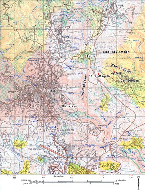
Region of Kh. el-Maqatir showing the locations of et-Tell, the site most scholars identify as Joshua’s Ai; el-Bireh, the most likely candidate for Bethel; and Beitin, the only viable possibility for Beth Aven.
Geographical Correspondences between Joshua’s Ai and Kh. el-Maqatir
Ai Must Be a Strategically Significant Site (Jos 7:2)
Kh. el-Maqatir is located on the southern bank of the Wadi el-Gayeh, which was the border between the central area of the highlands, under the control of the city-state of Shechem (Wood 1997), and the territory of Jerusalem to the south. From Kh. el-Maqatir there is clear line-of-sight communication with Jerusalem. Based on its strategic location and archaeological findings there, Kh. el-Maqatir appears to have been a northern border fortress for the Jerusalem city-state at the time of the Conquest. After the Israelites defeated Jericho (Jos 2–6), thereby gaining a foothold in the Promised Land (Cis-Jordan), Joshua sent spies to Ai in the highlands to the west (Jos 7:2). Ai clearly was important in Joshua’s overall military strategy for conquering Cis-Jordan. After eliminating the “early-warning system” of Ai (Jos 7–8), the Israelites conducted a campaign against a coalition of southern city-states led by Jerusalem (Jos 10). Thus Kh. el-Maqatir is consistent with the Biblical description of Ai as a militarily important site that needed to be eliminated prior to conducting a southern campaign.
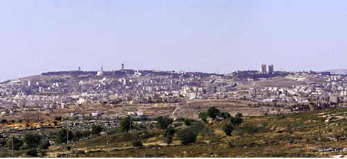
View from Kh. el-Maqatir to Jerusalem 9 mi to the south. On the left is the Mount of Olives and on the right are hotels in Jerusalem’s City Center. The geography of the region suggests that the fortress at Kh. el-Maqatir was the northern border fortress for the city-state of Jerusalem, which was the head of a coalition of southern city-states defeated by the Israelites (Jos 10). (Photo by Michael Luddeni)
Near Beth Aven (Jos 7:2)
When Joshua described the location of Ai to the spies, he said it was “near Beth Aven” (Jos 7:2). The Hebrew word used here, ‘im, means “close to, beside.” The most likely location for Beth Aven is Beitin (Wood 1999a); Kh. el-Maqatir is just 1 mi southeast of Beitin.
East of Bethel (Jos 7:2)
Joshua further told the spies that Ai was “to the east of Bethel.” The best candidate for Bethel is el-Bireh (Livingston 1998); Kh. el-Maqatir is east of el-Bireh.
Near Bethel (Jos 12:9)
In the list of defeated kings in Joshua 12, Ai is described as being “missad Bethel,” meaning “in the vicinity of” Bethel. Kh. el-Maqatir is 2 mi east of el-Bireh. Bethel was aligned with Ai, as the men of Bethel joined forces with the men of Ai in fighting the Israelites (Jos 8:17).
An Ambush Site West of Ai (Jos 8:9, 12)
Joshua placed an ambush force (or forces) “between Bethel and Ai, to the west of Ai” (Jos 8:9, 12). This requirement is met by the Wadi Sheban between el-Bireh and Kh. el-Maqatir. It is a very deep valley, hidden from view from both Kh. el-Maqatir and el-Bireh.
A Militarily Significant Hill North of Ai (Jos 8:11, 13)
When the Israelite army arrived at Ai, Joshua and his generals “set up camp north of Ai, with a valley between them and the city…they had the soldiers take up their positions—all those in the camp to the north of the city and the ambush to the west of it” (Jos 8:11, 13). Jebel Abu Ammar, 1 mi north of Kh. el-Maqatir, is the highest hill in the region and would have been an excellent command post from which Joshua’s generals could have viewed the entire battle field.
A Shallow Valley North of Ai (Jos 8:13–14)
Joshua did not remain with the main army, but rather took a small diversionary force and spent the night in the valley between the camp and Ai (Jos 8:13). This mimicked the small force that initially attacked Ai and was defeated (Jos 7:4–5). “When the king of Ai saw this, he and all the men of the city hurried out early in the morning to meet Israel in battle” (Jos 8:14). The valley north of Ai must have been a shallow valley in order for the king of Ai to observe Joshua and his men. The Wadi el-Gayeh between Kh. el-Maqatir and Jebel Abu Ammar is just such a valley.
Archaeological Correspondences between Joshua’s Ai and Kh. el-Maqatir
Fortified at the Time of the Conquest
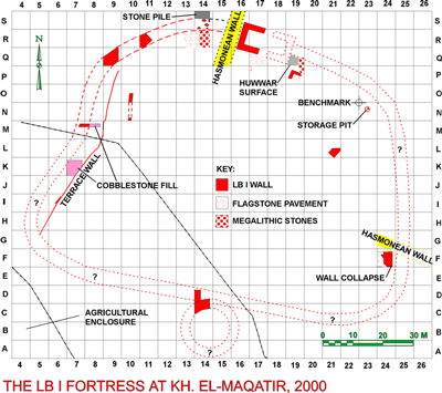
Since a gate figures prominently in the account of the capture of Ai (Jos 7:5; 8:29), it can be assumed that the site was fortified. Already in the first exploratory season in 1995, a large lower gate socket stone was discovered. Subsequent seasons revealed the west chamber of a two-chambered gate, as well as an additional lower gate socket stone and an upper gate socket stone (Wood 1999c: 28). Pottery found in conjunction with the gate dates to the Late Bronze I period (ca. 1500–1400 B.C.; Wood 2008: 231–36), the time of the Conquest. The east chamber of the gate has not survived as the stones were robbed out by later occupants, probably during the Hasmonean period (167–37 B.C.) when another fortress was built over the east half of the Late Bronze I citadel. Excavations from 1996 to 2000 uncovered sections of the Late Bronze I fortress wall 12–13 ft wide on the north, west and south sides of the enclosure.
Gate on the North Side of the Fortress (Jos 8:11)
When Joshua arrived at Ai with the “whole army” (Jos 8:1, 3), he was “in front of” Ai on its north side (Jos 8:11). The “front” of the fortress would have been the side where the gate was placed. Therefore, an important archaeological requirement for any contender for Ai is that it has a gate on its north side. The gate at Kh. el-Maqatir is on the north side of the fortress.
Smaller than Gibeon (Jos 7:3; 10:2)
When the spies came back from Ai they reported to Joshua that “only a few men are there” (Jos 7:3), indicating that Ai was a small place. This is further quantified in Joshua 10:2 where it is recorded that “Gibeon…was larger than Ai.” In the Middle Bronze Age period (ca. 1800–1500 B.C.) Gibeon was ca. 7 acres in size (Broshi and Gophna 1986: 74, 82). We can assume that it was about the same size in Joshua’s day. The Late Bronze I fortress at Kh. el-Maqatir is much smaller than Gibeon as it occupies an area less than 3 acres.
Destroyed by Fire (Jos 8:28)
After defeating the armies of Ai and Bethel “at a certain place overlooking the Arabah [wilderness]” (Jos 8:14) the Israelites returned to the fortress and “killed those who were in it” (Jos 8:24). They then plundered the fortress (Jos 8:27) and set it ablaze (Jos 8:28). Abundant evidence that the Late Bronze I fortress was destroyed by fire, such as ash, reheated pottery, burned stones and calcined bedrock, has been found at various places on the site.
A Ruin Forever (Jos 8:28)
“So Joshua burned Ai and made it a permanent heap of ruins, a desolate place to this day” (Jos 8:28). Following the destruction of the Late Bronze I fortress it was abandoned and left exposed to the elements, later scavengers and the farmer’s plow. Much of the eastern half of the Late Bronze I fortress was robbed out by the later Hasmonean builders. The western half was similarly robbed out when the Byzantine church and monastery was constructed on the summit of the hill 220 yds to the northwest. Subsequent to the Byzantine period there has been additional looting of the site. The foundation of the west half of the gate and remnants of the fortress, however, have survived. These sparse remains are visible on the surface or can be found just below the surface. Despite the plundering over the centuries, there remains a “permanent heap of ruins” at Kh. el-Maqatir yet today.
Highlights of the 2009 Season
Excavations in the 2009 season focused on the fortification system and a building complex inside the gate.
Fortification System
Excavations in the gate passageway revealed apparent evidence of severe burning in the form of reddened and fragmented bedrock, and burned and calcined building stones. On the west side, a 5 m length of the fortress wall was exposed and a 4 ft wide trench cut through it to provide a cross-section of its construction. At this point the wall is 12 ft wide at its base and preserved to a height of 4 ft. Several exploratory squares excavated on the south and east sides of the fortress in an effort to locate the fortification wall in these areas proved unsuccessful.
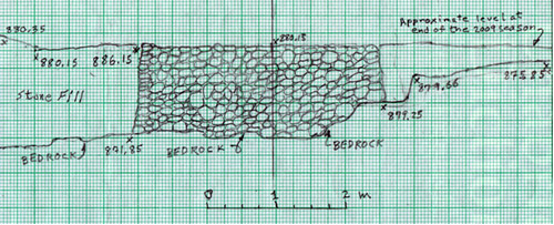
Cross-section of the west fortress wall. The best-preserved portion of the wall yet found, it is 12 ft wide at the base and preserved to a height of 4 ft. (Drawing by Oral Collins)
Building Complex inside the Gate
An infant jar burial was discovered between two walls in the northeast corner of the excavation square. Bones found in the vicinity proved to be those of an infant not more than 6 months old. The grave goods consisted of a store jar with its mouth facing south, a small cooking pot, a chalice and a dipper juglet. The pottery will be important for dating the fortress. In addition, the find supports another minor detail in the Biblical account of the defeat of Ai. The summary of the victory states, “Twelve elephs [of] men and women fell that day—all the people of Ai” (Jos 8:25). The fact that an infant was buried at the fortress implies that women were living there. This discovery provides yet another point of agreement between the finds at Kh. el-Maqatir and the many details given in the Biblical narrative concerning Ai.
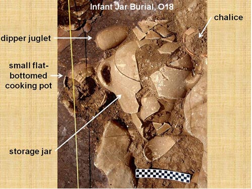
Infant jar burial found at Kh. el-Maqatir during the 2009 season, view south. This find indicates that there were women living in the fortress at Kh. el-Maqatir, in agreement with the Biblical statement that there were women at Ai (Jos 8:25). (Photo by Michael Luddeni)
Bibliography
Livingston, David P.
1998 Locating Biblical Bethel. Bible and Spade 11: 77–84.
2003 Khirbet Nisya: The Search for Biblical Ai 1979–2002. Manheim PA: Associates for Biblical Research.
Wood, Bryant G.
1997 The Role of Shechem in the Conquest of Canaan. Pp. 245–56 in To Understand the Scriptures: Essays in Honor of William H. Shea, ed. David Merling. Berrien Springs MI: The Institute of Archaeology/Siegfried H. Horn Archaeological Museum.
1999a Beth Aven: A Scholarly Conundrum. Bible and Spade 12: 101–108.
1999b Kh. el-Maqatir 1999 Dig Report. Bible and Spade 12: 109–14.
1999c The Search for Joshua's Ai: Excavations at Kh. el-Maqatir. Bible and Spade 12: 21–30.
2000 Kh. el-Maqatir 2000 Dig Report. Bible and Spade 13: 67–72.
2008 The Search for Joshua's Ai. Pp. 205–40 in Critical Issues in Early Israelite History, eds. Richard S. Hess, Gerald A. Klingbeil and Paul J. Ray Jr. Winona Lake IN: Eisenbrauns.